


Southeastern US Tornado Outbreak (21-22 January 2017)
Early in the morning on Saturday, 21 January, a strong tornado struck the cities of Hattiesburg and Petal, MS, damaging nearly 1,000 structures and causing 4 fatalities. The impacts signaled the start of a tornado outbreak across the following 48 hours that resulted in over 70 confirmed tornadoes – one of the largest tornado outbreaks ever observed in January. Apart from Hattiesburg, MS, the most widespread damage occurred in Albany, GA where an EF3 tornado was on the ground for over 70 miles, with a maximum damage path width of nearly 1.5 miles in some places. In response, the UF WHDAG culled information from online sources to summarize the tornado outbreak, and followed up with a field investigation of the Albany, GA tornado. We were happy to be joined in the field by a research team from the University of Illinois at Urbana-Champaign and others from the University of Georgia and the University of North Carolina-Asheville.
Our report, linked here, provides a summary of the entire outbreak as well as a preliminary summary of the field investigation methods and findings. A more comprehensive report will be finished and shared in the near future.

A church in Albany, GA destroyed by the tornado
Christmas Tornado Outbreak (23-27 December 2015)
2015 had been a reasonably active year for tornadoes but as of mid-December tornado-related fatalities was extremely low, at only 10 deaths – five less fatalities than the record low 1986 yearly total. All that changed in the week of Christmas, which saw 38 tornadoes, 47 weather-related fatalities and 2,000 damaged or destroyed structures spread over five states. Our WHDAG report summarizes the damage from this outbreak and focuses on the heavy damage sustained by the cities of Garland and Rowlett, TX, just northeast of Dallas where over 1,200 homes were damaged or destroyed. The WHDAG followed up this report with a site visit to Garland and Rowlett. Details of the visit and the key findings will be coming soon.
Find the WHDAG summary report here.

Johns Island Tornado (25 September 2015)
In the early morning hours of Friday, the 25th of September, a tornado quickly formed within a convective band moving ashore from off the coast of South Carolina. The tornado touched down on Johns Island, in Charleston County, SC, around 12:38 AM and remained on the ground for almost 7 miles, leaving a path of damaged homes and downed trees that was up to 0.5 miles wide. Thankfully there were no fatalities or even major injuries, despite it being a nighttime tornado, which typically leave residents little time to prepare and seek shelter. The National Weather Service rated it an EF2 on the Enhanced Fujita Scale with an estimated maximum wind speed of 130 mph.

The University of Florida Wind Hazard Damage Assessment Group report linked below summarizes the damage using publicly available information from social median and local news sources. Our report focuses on the fact that despite the relatively long and wide path, only one home suffered major damage that will likely require it to be rebuilt. We hypothesize that this can at least partially be attributed to the wind resistant building codes that have been in use in Charleston County for the past couple decades. Implications of this with respect to the EF Scale, the damage-based scale use to rate tornado intensity, are also discussed.
9 April 2015 Illinois Tornado Summary Report
Posted on April 27, 2015

Link to 9 April 2015 Illinois Tornado Summary Report
As if on cue, April 2015 saw the first tornado outbreak for the season, and we are pleased to issue our third online damage report for the year. This report’s focus is on a continental US wind event. We focus on the tornado outbreak’s characteristics as a whole and specifically on the EF-4 tornado that damaged houses in the town of Fairdale, IL; a location that experienced the brunt of the damage.
A secondary and equally interesting research enquiry for us was to analyze effects from an Hypothetical Tornado having the same strength, path length and width, but that follows a path 45 miles due east of Fairdale. The hypothetical path represents a tornado that would affect a densely populated north-west Chicago suburb. Follow the link to our report on the April 9th, 2015 Illinois Tornado.
Tropical Cyclone Olwyn (Australia) Rapid Damage Report
Posted on Mar 19, 2015
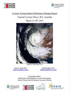
Link to TC Olwyn Rapid Damage Assessment Report
Download our recent preliminary damage report done on Cyclone Olwyn, A Category 3 tropical cyclone, which made landfall West of Exmonth, Western Australia. This cyclone, with maximum 3 second gust of 112 mph, made landfall on the 13th of March 2015. This report was prepared predominantly from media-sourced content by the Cyclone Testing Station at James Cook University and engineering faculty and students at the University of Florida.
Tropical Cyclone Marcia (Australia) Preliminary Damage Report
Posted on Feb 23, 2015

Download our recent preliminary damage report done on Cyclone Marcia that made landfall in Queensland, Australia. This cyclone made landfall on 16 February 2015. This rapid compilation of information was prepared mainly from online sources.
We are very pleased to welcome the participation of the James Cook Cyclone Testing Station, and its Director, Dr. David Henderson, who has come on board the preparation of these damage reports and who kindly allowed us to participate on this our first preliminary International Damage Report.
Online Damage Summary of June 16-18, 2014 Tornado Outbreak
Posted on June 23, 2014

While damage was observed in several communities, a number of communities also narrowly avoided the impacts of strong tornadoes. The probability of a tornado strike is low, but communities can still work to strengthen their infrastructure and disaster response so that they are ready for what seems to be the inevitable strike. For many small towns, the decisions made now may impact whether they are still in existence after a future tornado strikes… Continue on to report: Summary of June 16-18, 2014 Tornado Outbreak
Summary of Damage from 8 June 2014 Severe Storm in Alachua
Posted on June 11, 2014

Link to Alachua 8th June 2014 Severe Storm UNIV FLORIDA
On Sunday, June 8, 2014 the Storm Prediction Center issued a severe thunderstorm watch for portions of Northwest Florida, Southern Alabama, and Southwest Georgia, lasting from 1:50pm to 9pm CDT. The chances for a combined severe hail and wind event was 60%.
The outlook was accurate, with an estimated maximum wind gust of 60 MPH in North Florida and Alachua County experiencing the presence of strong straightline winds and convective precipitation.
The University of Florida Wind Hazard Damage Assessment Team performed a detailed survey of areas with significant structural damage. The Majority of the damage consisted of fallen and snapped trees, roof damage from fallen trees and branches, a few downed power lines, and flooding. One person sustained a minor injury. Continue on to report: Damage Summary 8 June 2014 Severe Storm in Alachua County
Preliminary Report on the April 27, 2014 Tornado Outbreak Issued
Posted on April 30, 2014
 “A significant outbreak of severe thunderstorms spawned ten confirmed tornadoes that rapidly moved through Oklahoma, Kansas, Iowa, Arkansas and Louisana on Sunday, 27 April 2014. One particularly damaging system produced a tornado on the ground for almost 80 miles, causing catastrophic damage to the towns of Mayflower and Vilonia. Preliminary reports indicate this tornado will be rated at least EF-3. Sixteen direct fatalities have been reported for 27 April, 2014 alone, 14 of which occurred in the towns of Mayflower and Vilonia. The other fatalities occurred in Quapaw, OK (1 fatalities) and White County, AR (1 fatality). This is part one of a two-part report, as the severe weather from 27 April, 2014 continued through the 28th and 29th as well…”
Report on Building Collapse of Wood-Framed Structure in Moderately Strong Wind Gust, N.C. Issued
Posted on January 14, 2014
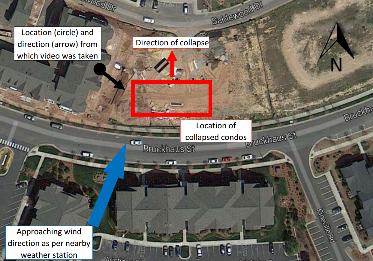
Location of collapsed condos with respect to captured video and approaching wind angle (Figure 5 from Brier Creek Damage Report)
 The January 11th, 2014 dramatic collapse of two condominiums under construction in Brier Creek, NC may be the result of wind loads estimated to be less than 75% of the ASCE 7-05 design wind loads, adopted in the North Carolina Building Code in 2012.
The first condominium, a 3 story condo, was fully framed and had exterior wood sheathing on both its north and south exterior faces. The other was also fully framed but had wood sheathing only on the south facing exterior wall. Using the video footage and photographs provided by CNN, we were able to observe soft-story failure mechanisms and brittle failures, occurring at the mechanical connections between sheathing and framing elements… (Read more on the January 11th, 2014 Wind Damage to Brier Creek Condos)
The purpose of this rapid, preliminary online assessment is to stimulate discussion among engineers, meteorologists, builders and the wider community regarding the wind resistance required for light-framed wood structures.
Click here to read the response from the Toll Brother’s, the Pennsylvania-based company that is building the project.
- “Two longtime City of Raleigh building inspectors said they had not seen anything like this at a construction site before… ” Read more on the Toll Brother’s reponse
Preliminary Report on the Illinois Tornado Outbreak Issued
Posted on November 20, 2013

Link to Illinois Tornado Outbreak 17-November-2013 Summary
“A significant outbreak of severe late-season thunderstorms spawned a series of tornadoes that
rapidly moved through Central Illinois, Indiana, Kentucky, Missouri, Michigan, and Ohio on
Sunday, November 17 2013. There have been at least 45 confirmed tornado sighting within this
system; they caused significant damage in towns in Illinois, Indiana and Kentucky. Two
tornadoes in Illinois have been rated EF-4– a first for November tornado outbreak in that state.
Six direct fatalities have been reported, occurring in New Minden, IL (2 fatalities), Washington,
IL (1 fatality) and Massac County (3 fatalities in a mobile home park). The tornadoes ended just
shy (5 miles to south-east) of Chicago’s city limits. Had they continued further…”
Congratulations to Dr. David O. Prevatt on Career Milestone!
Preliminary Report on the Jacksonville, FL Tornado Issued
Posted on August 9, 2013

Link to Jacksonville, FL Tornado 1-August-2013 Summary
“Jacksonville, Florida, a city of 836,507 (in 364,678 homes), was hit by a tornado on August 1, 2013. Preliminary estimates by the National Weather Service placed its strength as EF-2. This area, (Duval County, FL) has been hit by 61 tornadoes over the past 64 years. The tornado touched down around 4:15pm and in 15 minutes, it tracked in northeasterly direction for approximately three miles through the Arlington Jacksonville area. The maximum damage swath of the tornado was mapped at about 135 yards. The majority of the damage consisted of…”
Preliminary Report on the Moore, OK Tornado Issued
Posted on May 23, 2013

Link to Moore Tornado 20-May-2013 Summary
“Nearly two years to the day after Joplin, MO is hit by the EF-4 tornado, Moore, OK is impacted by another powerful tornado resulting in substantial damage to houses, schools, and several fatalities. The National Weather Service classified the tornado as an EF-5 and parts of the damage path were mapped at nearly 2 miles wide. Statistically, such powerful tornadoes have very low probability of occurrences, but by cruel twist of fate, Moore, OK has seen three powerful and destructive tornadoes since 1999…”
Preliminary Report on the North Texas Tornado Issued
Posted on May 23, 2013

Link to May 5th North Texas Tornado Summary
“Within 8 hours 16 tornadoes were spotted within an area located two hours west of Dallas, TX. Within that time there were at least 6 fatalities, over a hundred injuries and dozens of single-family homes damaged or destroyed. Mobile homes were blown off their foundations, and the slab of site-built homes were swept clean. The National Weather Service assigned an EF-4 rating to the most powerful tornado in Granbury, TX, and lower ratings to others. At this time, there’s limited photographic evidence available online for most of the damage but from the available information, similar failure patterns as were observed in the 2011 tornado outbreaks in Tuscaloosa, AL and Joplin, MO are apparent. The damaged homes, constructed as light-framed wood structural systems, lack component of a vertical load path (i.e. metal hurricane ties, large steel washers on wall plate anchor bolts) that could have given some homes a “fighting chance” to survive a tornado…(read more)
Moore Oklahoma Pre-Tornado Imagery Map

Click here to View before and after satellite images of the area affected by the Moore, Oklahoma tornado of May 2013 using the new Google Crisis Response map. Slimply go back and forth with a slider to instantly compare post and pre-tornadic images of Moore, OK.
Also click here to view specific sites affected by the storm. Just slide the bar from side-to-side to see before and after photos.